1. Understanding Real Estate Aerial Photography
1.1 What is Aerial Photography in Real Estate?
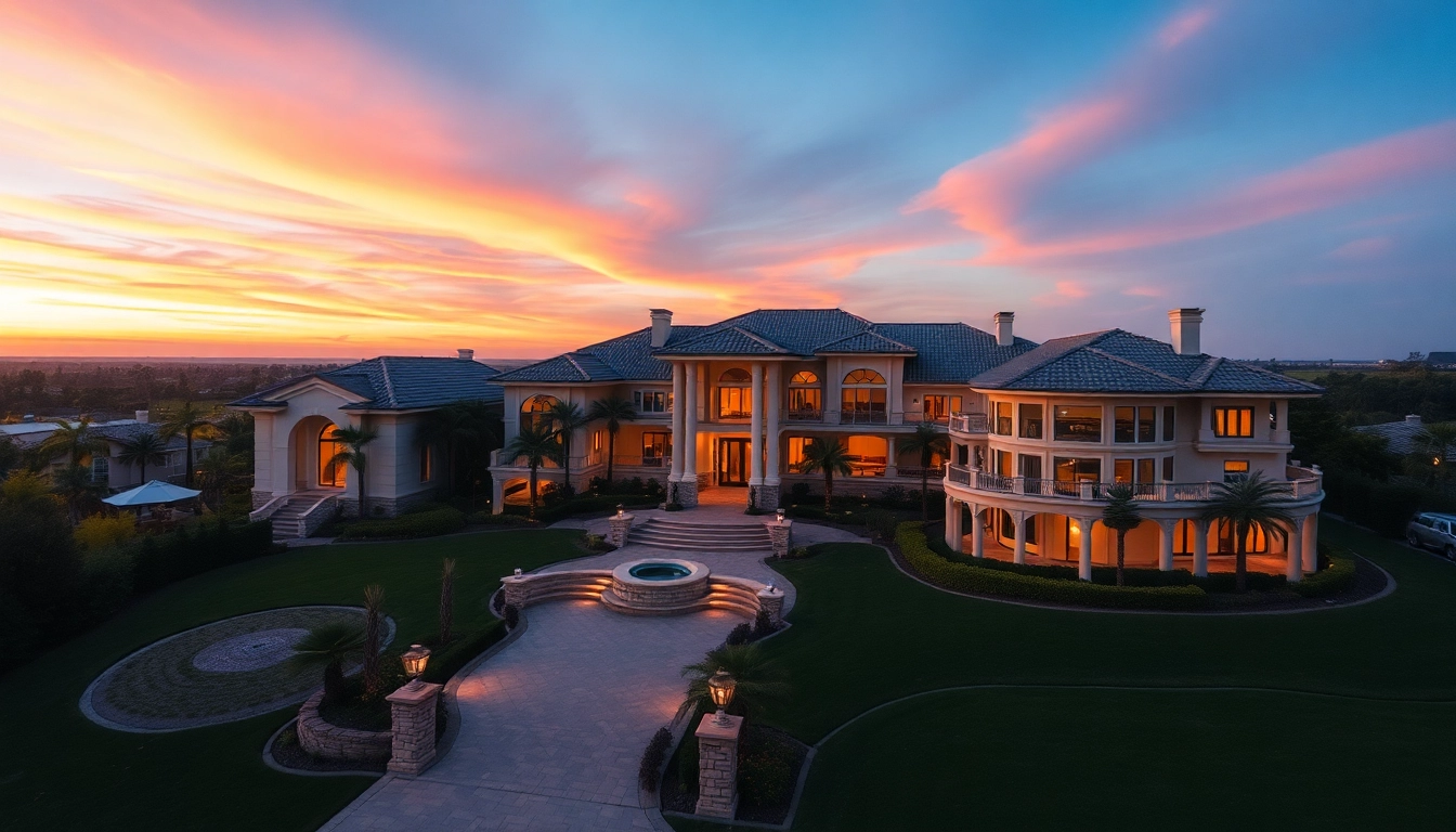
Aerial photography in real estate involves capturing images of properties from an elevated or bird’s-eye view, typically using drones or helicopters. This innovative approach allows potential buyers to engage with a property’s scale, layout, and location in a manner that ground-level photography simply cannot achieve. As real estate markets become increasingly competitive, agents and property owners are turning to real estate aerial photography to showcase properties in a more dynamic and comprehensive way, ultimately enhancing their marketing strategies.
1.2 Benefits of Aerial Photography for Real Estate Marketing
The application of aerial photography in real estate marketing brings numerous advantages. First and foremost, aerial images provide an unparalleled perspective that highlights the property’s surroundings, including landscaping, outbuildings, and neighboring amenities. This broader context adds significant value by helping potential buyers understand the property’s position with respect to its environment.
Aerial photography also generates stunning imagery that stands out in a crowded online listings market. High-quality aerial shots can grab the attention of viewers, increasing engagement levels and likelihood of inquiries. Moreover, these images may also enhance the perception of the property’s value, often resulting in a higher sales price.
Additionally, using aerial photography helps in portraying large properties, difficult terrains, and urban developments effectively—showcasing features that traditional photography might miss. This comprehensive presentation is crucial in attracting the right clientele, particularly luxury buyers who expect high-quality visuals in their property search.
1.3 Types of Aerial Photography Techniques
When it comes to aerial photography in real estate, several techniques can be employed to capture dynamic images:
- Drone Photography: The most common method, involving small, remote-controlled flying devices equipped with high-resolution cameras.
- Helicopter Photography: Typically used for larger estates or when capturing expansive areas, helicopter photography enables longer flight times and higher altitudes.
- Plane Photography: Ideal for large developments or for capturing vast landscapes, aerial shots taken from small planes can cover significantly more ground.
- Photo Mosaics: A technique that stitches together multiple images to create a comprehensive bird’s-eye view of a property, providing detailed context.
2. Preparation for Aerial Photography Shoots
2.1 Choosing the Right Time and Weather Conditions
Successful aerial photography shoots rely heavily on timing and weather conditions. Early mornings or late afternoons are often best, as the softer light produces flattering images with less harsh shadows. Furthermore, clear skies yield bright and colorful shots, while overcast conditions can lead to dull and flat images. It is also vital to monitor wind conditions, particularly with drone photography, as high winds can lead to unstable aerial shots.
2.2 Essential Equipment for Capturing Aerial Shots
Having the right equipment is crucial for capturing stunning aerial photographs. Essential tools include:
- High-Quality Drone: Invest in a drone with a high-resolution camera capable of capturing crisp images and video. Brands like DJI offer excellent options.
- Camera Accessories: Filters, such as polarizers, improve color saturation and contrast in aerial images.
- Spare Batteries: Extended flight time allows for more shot opportunities, ensuring a comprehensive capture of the property.
- Editing Software: Tools like Adobe Lightroom and Photoshop can help in enhancing the final images, ensuring the best presentation.
2.3 Planning Your Shots: Angle and Viewpoint Considerations
Planning the angles and viewpoints for your aerial shots is essential to tell the property’s story effectively. Consideration should be given to:
- Bird’s Eye View: A direct overhead shot that showcases the property layout and its surroundings.
- Oblique Angles: Capturing the property from a slight angle can provide depth and context.
- Highlighting Features: Focus on specific features such as pools, gardens, or outdoor living spaces, which are often significant selling points.
- Surrounding Context: Showcasing nearby amenities, parks, and schools can help potential buyers understand the advantages of the location.
3. Techniques to Enhance Your Aerial Photography
3.1 Composition Tips for Eye-Catching Images
An eye-catching composition is fundamental to effective aerial photography. Apply the principles of photography, such as the rule of thirds, to create balanced and interesting images. Position key elements of the property at intersection points or along the grid lines. Leading lines, such as pathways or fences, can draw the viewer’s eye towards the property, creating a sense of depth.
Incorporating foreground elements can enhance the perception of scale and distance as well. Avoid clutter and distractions in the frame to keep the viewer’s focus on the property. Lastly, consider including some sky in the composition to add an expansive feeling, emphasizing the “aerial” aspect of the photography.
3.2 Utilizing Drones for High-Quality Resolutions
Drones have revolutionized aerial photography, offering versatility in capturing high-quality images from perspectives that were once difficult to achieve. Modern drones equipped with 4K cameras produce sharp, vivid images that draw the viewer in. For real estate, it’s vital to use drones that provide stability and have features such as GPS tracking, obstacle avoidance, and live feed capabilities to ensure the best possible shoot.
3.3 Editing Tips for Perfecting Aerial Photos
Post-processing is a crucial step in aerial photography, allowing you to elevate your images from good to extraordinary. Adjustments in exposure, contrast, and color correction can make a significant difference in the final photos. Utilize tools like cropping to remove distractions and enhance composition. Additionally, sharpening the image will ensure that it appears crisp on listing platforms. Don’t hesitate to experiment with HDR techniques to highlight details in both shadows and highlights, ensuring a balanced exposure throughout the image.
4. Case Studies: Successful Real Estate Aerial Photography
4.1 Analyzing Effective Use of Aerial Images
Analyzing successful case studies provides insights into how aerial photography can transform real estate marketing. For instance, a luxury oceanfront property in California leveraged stunning aerial imagery to showcase its expansive views, landscaping, and proximity to the beach. The grand vista enabled potential buyers to appreciate not just the home but the lifestyle that accompanies it—leading to a quicker sale at a premium price.
4.2 How Aerial Shots Increase Property Interest
In another notable case, a residential development used aerial photography to highlight the community amenities, such as nearby parks, playgrounds, and walking trails. This strategic visual storytelling led to increased interest during open houses, with many attendees remarking on the compelling images they had seen online. Aerial photography effectively encapsulated the lifestyle and community atmosphere that prospective buyers were seeking, driving higher attendance and engagement.
4.3 Lessons from Top Real Estate Agents
Top real estate agents and firms that successfully employ aerial photography have several common practices. First, they prioritize high-quality visuals in their marketing materials and recognize the importance of capturing a property from multiple angles. Furthermore, these professionals often collaborate closely with experienced aerial photographers who understand real estate marketing. Their ability to convey a property’s story visually has proven key to successful selling, especially in competitive markets.
5. Measuring the Impact of Aerial Photography on Sales
5.1 Key Metrics to Evaluate Photography Effectiveness
Measuring the impact of aerial photography on the success of property listings requires considering several metrics:
- Click-Through Rates (CTR): Analyzing the CTR of listings with aerial images compared to traditional images can provide insights into the effectiveness of aerial photography.
- Inquiries and Showings: Track the number of inquiries and scheduled showings following the launch of a listing featuring aerial photography.
- Time on Market: Assess whether properties with aerial photography sell faster than those without.
- Final Sale Price: Compare the sale price of properties showcased with aerial photos against those without to gauge financial impacts.
5.2 Real-Life Examples of Increased Sales
A real-life example from a prominent real estate agency demonstrated that properties showcased with aerial photography tended to sell for an average of 20% more than comparable listings without such imagery. This statistic highlights how modern buyers are more inclined to pay a premium for listings that effectively engage them visually. Additionally, the engagement on listing platforms spiked significantly due to the captivating visuals, leading to increased competition among potential buyers.
5.3 Future Trends in Real Estate Aerial Photography
The future of real estate aerial photography is poised for further innovation, with advancements in drone technology and imaging capabilities enhancing the potential to present properties immersively. Integration with virtual reality (VR) and augmented reality (AR) technologies could enable prospective buyers to ‘fly over’ properties in real-time, providing a unique viewing experience. Marketing strategies may increasingly rely on video aerial tours, combining stunning visuals with informative narratives, offering a comprehensive view of the property and its surroundings.